Fred Olsen — through its renewables division — is proposing to build an industrial-scale wind farm on an ecologically sensitive high ridge on the edge of the Yorkshire Dales. Although the turbines themselves would not be located inside the National Park, their visual impact would extend deep into it, making them visible from a wide area of the Dales as well as several other protected landscapes.
Fred Olsen have also used misleading images to represent their plans, and given the project the benign-sounding name Hope Moor Wind Farm. Throughout this article, I refer to the scheme as the proposed Fred Olsen industrial-scale wind farm at Hope Moor, because this analysis concerns the reputational implications for the company, not the ecological assessment.
Given that the wider Fred Olsen Group also operates Fred Olsen Cruise Lines — which promotes sustainable and heritage-based travel — this raises questions about how consistently those values are applied across the Group’s businesses.
Background
Fred Olsen are proposing to construct an industrial-scale wind farm on a flat high ridge between Teesdale and Swaledale. The ecological and environmental damage of such a development has been discussed elsewhere. This article will focus on the damage to the landscape — the visual impact across several National Parks and Areas of Outstanding Natural Beauty — and what implications this may have for Fred Olsen’s reputation.
The analysis uses software to undertake a ZTV analysis (Zone of Theoretical Visibility) and Line of Sight analysis, showing how much of the Fred Olsen wind farm will be visible from within the Yorkshire Dales. It also assesses the combined impact on the Yorkshire Dales of the proposed Fred Olsen wind farm with the similar Calderdale Energy Farm that is also being proposed.
Proposed development
Fred Olsen intend to construct 20 wind turbines, each 200m (~650 feet) high – which is seven times higher than the nearest mobile phone mast and the same height as the tallest building in the UK outside London – the Deansgate Square South Tower in Manchester. The site is a rough elliptical shape – spanning Hope, Newsham, Kexwith, Holgate, and Barningham Moors – approximately 5km (~3 miles) wide, 3.5km (~2 miles) deep, and covering just over 11 square kilometres in total. The boundary of the site is marked in red in Figure 1.
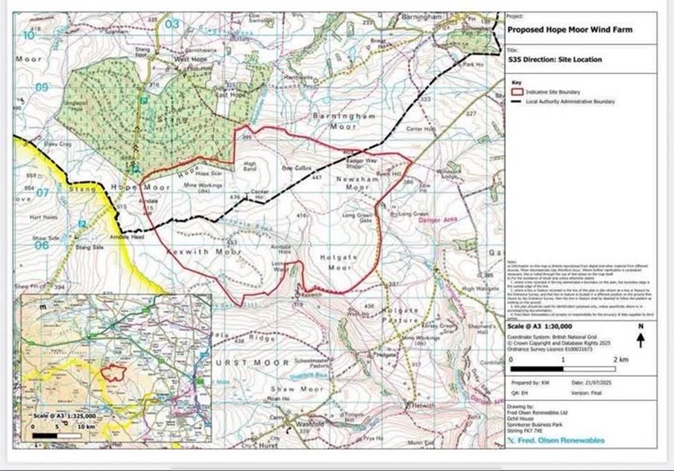
Figure 1: Boundary of proposed wind farm
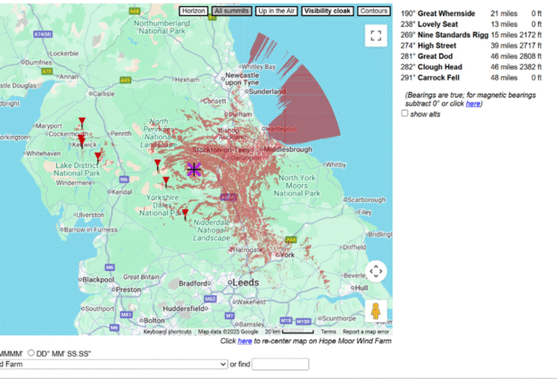
Zone of Theoretical Visibility
As an indication of the ZTV of the proposed Fred Olsen industrial-scale wind farm at Hope Moor, an analysis was requested from heywhatsthat.com using the following parameters:
- elevation 2074 ft above sea level (including 650 ft turbine structure height)
- latitude 54.455833 N
- longitude 1.906944 W
The resulting analysis is shown in Figure 2. Red areas indicate where the Fred Olsen wind farm would be visible (excluding the screening effects of vegetation and buildings).
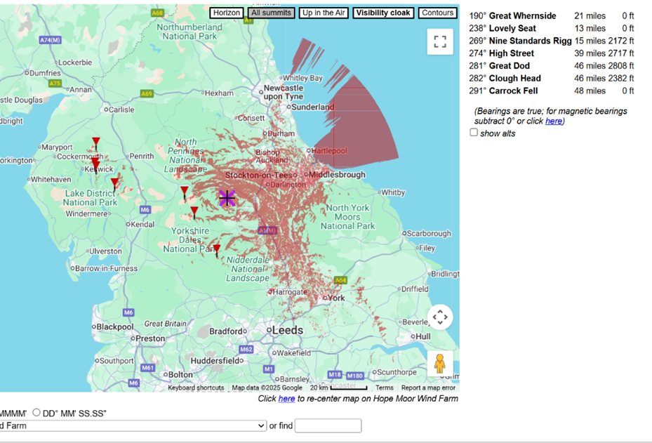
Figure 2: Indicative Zone of Theoretical Visibility
The software suggests that turbines at the proposed Fred Olsen wind farm could be visible across a very wide area, including the following designated landscapes:
- Yorkshire Dales National Park
- North Pennines Area of Outstanding Natural Beauty (AONB)
- Nidderdale AONB
- North York Moors National Park
- Lake District National Park (limited high-point visibility on the eastern fringe only)
In addition, visibility extends across several areas without formal landscape designation, including:
- County Durham
- Teesside and Tyneside
- North Yorkshire
- parts of York and East Yorkshire
- parts of West Yorkshire
- parts of the North Sea
Example viewpoint analysis — Little Whernside
To illustrate how the proposed Fred Olsen industrial-scale wind farm at Hope Moor would appear from a significant distance, a line-of-sight and angular visibility analysis was undertaken using a representative viewpoint on Little Whernside. This peak is ~600m (~2,000 feet) above sea level, within the Yorkshire Dales National Park, and close to the border with the Nidderdale AONB.
The distance between a ground-level reference point — within the proposed Fred Olsen wind farm site — and Little Whernside is 29.6km (circa 18 miles). The double image in Figure 3 is produced by Solwise and shows the line of sight, with the distance shown on a map (top image) and the relation to the ground on a schematic (bottom image).
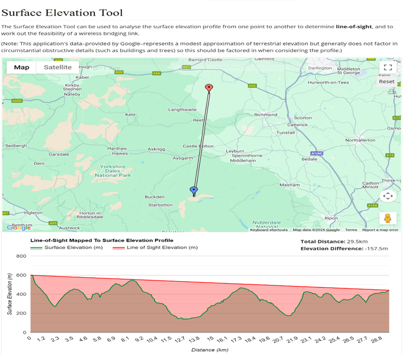
Figure 3: Solwise elevation analysis
Figures 4 and 5 are from Scadacore — software designed to assess the line of sight of mobile and other radio masts. In doing so, it also provides line-of-sight analysis for raised structures such as the 200-metre turbines at the proposed Fred Olsen wind farm.
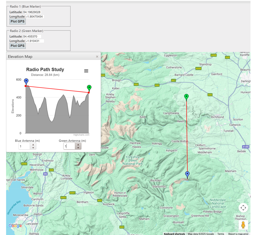
Figure 4: Line of sight from Little Whernside to base of wind turbine
Figure 4 (above) shows that, from the representative location on Little Whernside, the base of the Fred Olsen wind farm is visible and below horizontal.
Figure 5 (below) shows that, once a 200m (~650ft) structure is erected, the tops of the Fred Olsen wind turbines are visible and above the horizontal.
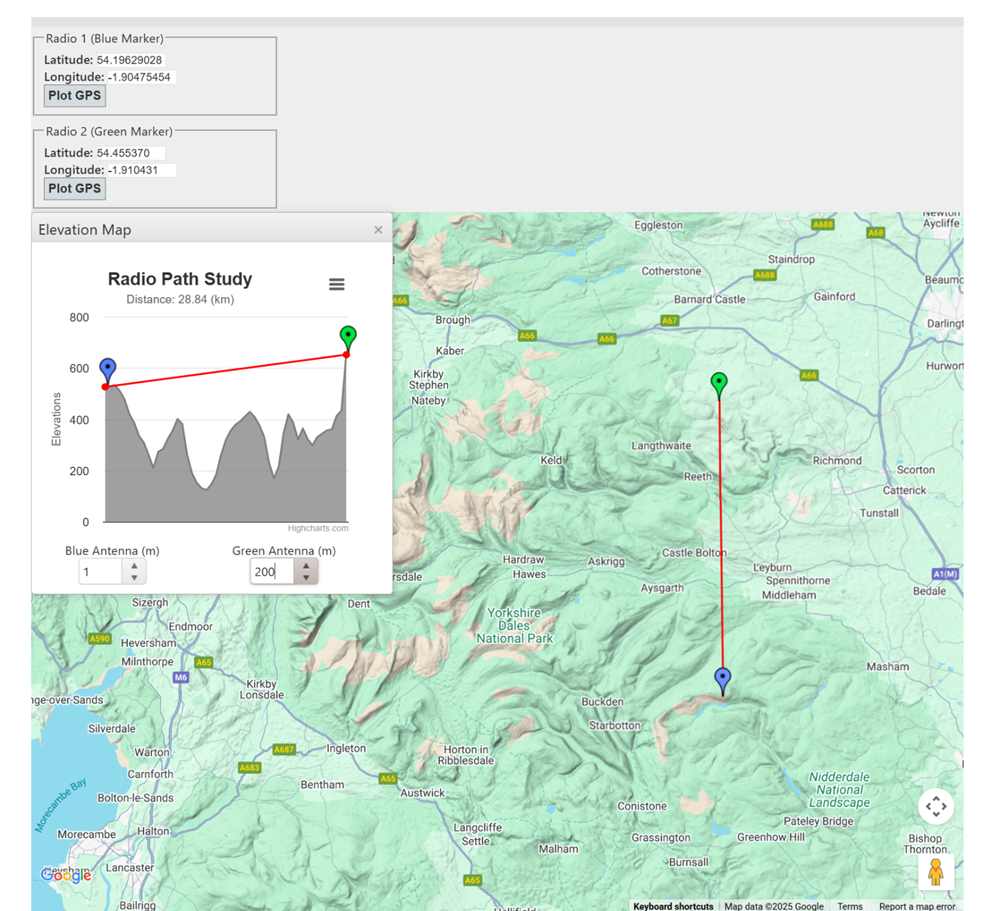
Figure 5: Line of sight from Little Whernside to top of wind turbine
Apparent size and field of view
At a viewing distance of 29 km, a 200m turbine would occupy circa 0.4 degrees in the vertical plane — roughly the apparent height of the sun or moon — whilst the 5 km horizontal envelope of the 20 wind turbines would occupy circa 10 degrees of the horizontal field of view — roughly the width of a clenched fist held at arm’s length. Although the ‘radio path’ images use exaggerated angles for legibility, even at that great distance, the visual presence of the proposed Fred Olsen wind farm within the Yorkshire Dales remains significant.
Scale of impact
Little Whernside is one example. The ZTV analysis shows that the proposed Fred Olsen industrial-scale wind farm at Hope Moor would be visible from the Lake District to the North Sea, from Tyneside to York — despoiling the landscapes of several National Parks and Areas of Outstanding Natural Beauty in the process.
What is currently a widely-loved and admired national park landscape would become visually dominated — in the north and east at least — by the Fred Olsen wind farm. It would become a permanent reminder of the damage done to our ecology, environment, and landscapes by the current ‘gold rush’ into industrial-scale wind farms in ecologically sensitive locations.
This conflicts with the values of a family-owned Group that, through its cruise line operation, promotes environmental and sustainability values. The dissonance between the Group’s stated values and the visual/landscape harm of this project is likely to be noticed — not only by campaigners, but by customers and partners who assume consistency across the Group’s activities. The proposed Fred Olsen wind farm is a reputational gamble the company may yet regret.
Calderdale energy park
The ZTV analysis below (Figure 6) combines the visual impact of the proposed Fred Olsen industrial-scale wind farm at Hope Moor with a similar scheme proposed in Calderdale. It shows that the combination of the two means that no region of the Yorkshire Dales will remain untouched. This internationally-renowned landscape will be lost forever.
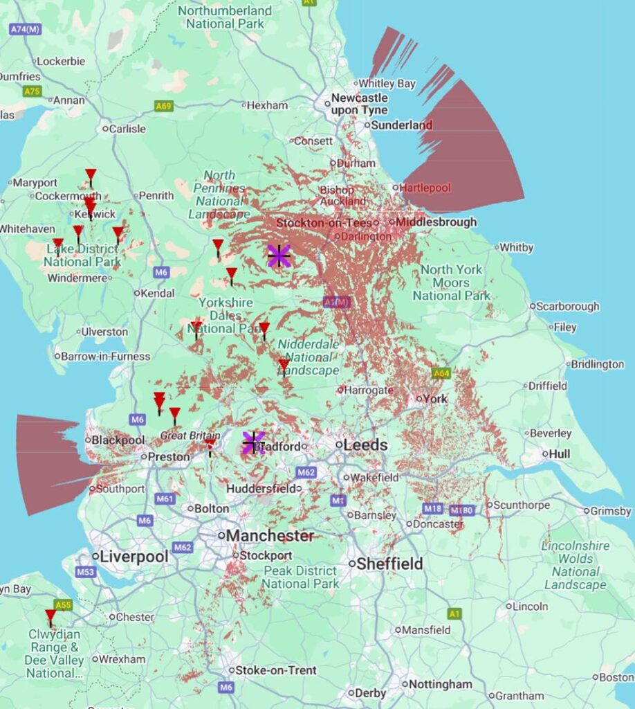
Figure 6: Combined Fred Olsen and Calderdale ZTVs
Conclusion
Across the Fred Olsen Group, reputation is built on trust, environmental responsibility, and alignment with the landscapes and communities its customers value. Proceeding with an industrial-scale development whose visual and ecological footprint would extend across multiple National Parks risks eroding that trust. It invites scrutiny not only of this project, but of how consistently the Group applies the environmental values it promotes. For a family-owned company that trades on heritage, stewardship, and public goodwill, the reputational cost of persisting with the Hope Moor proposal may ultimately outweigh any commercial gain.
